Hotels in Krambach, New South Wales
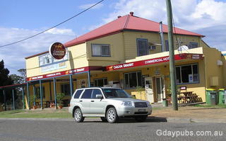
Commercial Hotel
"The two story part of the Commercial Hotel dates from the 1890's and the brick part on the right from the 1970's. I bet this hotel could tell a few good stories I was very tempted to stay for a couple of beers." Jon Graham
Information on Krambach, NSW

Krambach is a charming village in New South Wales' Mid-Coast Council area, located along the Bucketts Way southwest of Taree. With a population of 382 (2021 census), this scenic country stop serves as a delightful waypoint for travelers en route to Gloucester from the Pacific Highway.
The village boasts beautiful country views, friendly locals, cafes, and a local pub. Originally a beef cattle district, early pioneers diversified into crops before focusing on pastoral activities. Krambach offers visitors scenic allure and invites them to savor the peaceful rural atmosphere of the Barrington Coast.
Local tourism links
Travel options
Krambach is accessed via the Bucketts Way, which provides a scenic alternative route connecting the Pacific Highway to various destinations. The Bucketts Way continues eastwards from Krambach, ending at the intersection with Manning River Drive in Purfleet, just south of Taree near the Pacific Highway interchange. From the Pacific Highway, travelers can access Krambach by turning left onto the Bucketts Way approximately 20km north of the Raymond Terrace bypass roundabout.
The route offers access to Barrington Tops National Park and serves tourists seeking a picturesque drive through the NSW Mid North Coast hinterland.
- Nabiac (12km)
- Hallidays Point (21km)
- Wingham (21km)
- Taree (24km)
- Tuncurry (26km)
- Forster (28km)
- Cundletown (29km)
- Gloucester (29km)
- Old Bar (31km)
- Bulahdelah (40km)

